Maps
This is a work in
progress
Last update 19/11/06
The fact is that the railways were the driving force behind the industrial revolution in Furness. Before the railways, Furness was pretty well cut off from the rest of the world. Heavy loads were carted or pack horsed to the coast, loaded in small boats, trans-shipped to larger coasters, and generally man-handled. There were iron works and quarries but the products were mainly for local use - the area was largely self-sufficient. The railways provided cheap and fast transport to the growing markets of Manchester, Liverpool, Leeds, Birmingham and beyond. Not only did the railway provide a route to market for the slate and iron ore, it also delivered the coal needed for the steelworks which later developed in Barrow. And of course, it also brought the miners, iron workers, ship builders and labourers that we are descended from.
The impact of the railways can be seen no better than by looking at the
Armisteads. The earliest consistent source of information on
occupation is the 1841 census, which shows that at age 38, Robert
Armistead was an Iron Miner living in Stainton. He probably worked
in the Stainton and Adgarley Iron Mines, which probably looked like the
first OS map in the 1850s.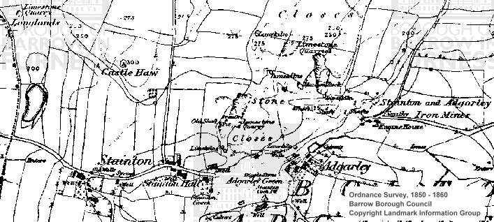
Here we have a fairly small limestone quarry, an iron ore pit and a number of shafts. There are small lime kilns scattered round the area but no sign of any major industry.
Robert's son James started life as a farm labourer but by 1871 he had joined the quarry work-force. All three of James' sons went into the business, Robert and George joining there father as limestone quarrymen whilst James followed his grandfather into the iron mines. However by 1881 there were obviously no jobs in the Stainton iron mines as James moved to Kirkby Ireleth to pursue his trade.
By the 1890s we can see how much the quarry has grown and the impact of the railways on the local area.
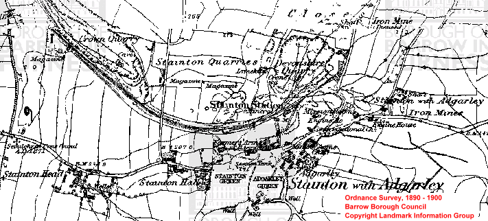
The quarry has been bought up by Devonshire to supply limestone for the new steelworks in Barrow, and he has laid the railway to move the mass of stone required. Another quarry has been developed beside the line, and the use of explosives is seen in the magazines scattered around the area. There is still an area labelled 'Stainton with Adgarley Iron Mines', but the shafts marked on the previous map are now under the quarry.
Interesting Links
Lancashire County Council Old Maps
http://www.dmm.org.uk/company/b031.htm
http://www.aboutulverston.co.uk/location/conisheadpriory.htm With thanks to web archives!
http://www.thisisthelakedistrict.co.uk/archive/display.var.238219.0
.quarry_road_saga_set_to_end.php
http://www.lindal-in-furness.co.uk/History/history.htm
http://www.answers.com/topic/furness